Today’s hiking route: photography and adventure
Leave the urban environment behind and discover the Sierra del Segura, where the mountainous landscape of El Sabinar will surprise you in every season with breathtaking views. Read the report here about an atmospheric, short route, perfect for days when the clouds create the most dramatic photographic moments.
El Sabinar
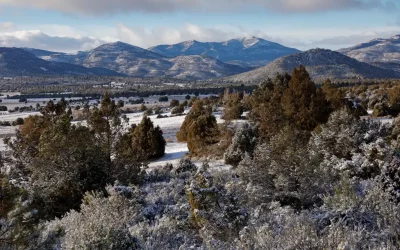
Whether the Spanish sun is shining or the clouds hang low, in the natural area of El Sabinar (Sierra del Segura), any day is a perfect opportunity to put on your hiking boots. This mountainous interior of Murcia conceals stunning views that you absolutely must discover.
Here is the short story of a brief hiking route, perfect for days when you want to enjoy nature but prioritize safety.

The Irresistible Magic of Mist and Clouds
We are accustomed to the clear blue sky in this part of Spain, ideal for a winter hike. But did you know that a cloudy and slightly rainy day offers good conditions for landscape photography?
Instead of the hard shadows and high contrast of the bright Spanish sun, a thick blanket of clouds acts as a gigantic, natural softbox. This creates soft and even lighting, perfect for capturing the depth and texture of the mountains. Furthermore, it yields intense colors where green, red, and brown stand out more than under a blue sky.
Today was a day like that: humid, quiet, and wrapped in a dark, atmospheric blanket. The ideal challenge for a photographer and an adventurous hiker.

The route: the highest point with beautiful views
For this outing, I chose a section of the route towards La Fuente de Sabina (which is just across the border, in the province of Albacete). Due to the weather conditions, I decided to keep the route short, which is an important lesson for mountain hikers.
The route begins in the heart of El Sabinar village, in the picturesque Plaza Mayor (1200 m). From there, I headed to the Plaza del Molino and followed the signs towards the Paisaje Riscas Sabinar street. This first part serves as a warm-up for the ascent. The trail took me on a constant and gradual climb, leaving the El Sabinar valley behind to enter the mountain.
Soon I reached an altitude of about 1400 meters. From this point, I enjoyed spectacular views of the valley, with El Sabinar deep below. The contrast between the dark, menacing clouds from the east and the valley’s depth was fascinating.
I crossed the border of the autonomous community to reach the Sierra de Zacatín, in the province of Albacete (Castilla-La Mancha). The highest and final point of this short route is Majal Alto, situated at 1423 meters above sea level. After reaching this summit and enjoying the panoramic views, I began the descent along the same path back to the starting point.
Hiking in cold and Humid Conditions
Walking in humid, windless conditions is wonderfully relaxing but requires caution.
When the environment is damp, all stones and rocks in the mountainous area can be treacherously slippery. Long, risky routes are not advisable. Enjoy the beauty, do not stray from your path, stay on the trails, and know when to turn back.
Upon reaching the highest point, I decided to interrupt the walk and turn back. In the mountains, it is better not to take unnecessary risks in cold or wet weather.

An Unexpected Sunset
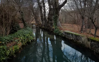
Once back in the valley, we were treated to a breathtaking spectacle. Just before the sun definitively disappeared behind the clouds, it broke through for a moment! This created a beautiful orange-red glow on the hills and the underside of the clouds.
After a short but intense two-hour walk, this “wet” day resulted in a collection of beautiful, atmospheric landscape photographs. It proves that the beauty of nature in El Sabinar always surprises, regardless of the weather forecast.
Ready to conquer the mountains of Murcia?
Put on your hiking boots and don’t forget your camera, because the perfect photo awaits you, even (or especially) if the sun decides not to show itself. If you would like to know more about the hiking possibilities in this wonderful area, please do not hesitate to contact me.
More information (Spanish)
Hiking in Murcia
Escuela de Montaña de Santo Ángel
Federación de Montañismo Regio de Murcia
Mapa topográfico Murcia