A Historical and Enigmatic Monument
The Verdolay Castle, also known as the Castle of Light or the Castle of Santa Catalina, and more colloquially as the Moorish Castle, is located 6 km south of the city of Murcia (Spain). In this article, we take you on a journey through the history of this unique building, one of the oldest castles in Spain.
Since prehistoric times
The area where it is located has been inhabited by humans since prehistoric times, and as we have seen in previous works, this site has been a mystical and religious place since time immemorial; first with the Iberian Sanctuary of La Luz, and later with the presence of hermits who lived in caves (later gathered in the hermitage of La Luz and the Convent of Santa Catalina), in addition to the presence of the Sanctuary of Fuensanta and the numerous convents of nuns existing in the surroundings.
")
The Verdolay Castle and a view of the water cistern (Aljibe in Spanish)
Crown of Castile
The castle, listed as a BIC (Site of Cultural Interest or in Spanish, Bien de Interés Cultural), was built in the early centuries of Islamic domination (8th-9th centuries), making it one of the oldest in Spain, and well before the foundation of the city of Murcia. It is believed to have been abandoned in the mid-13th century, when Murcia was incorporated into the Crown of Castile, due to the great depopulation that occurred in the territory.
Description of the Castle
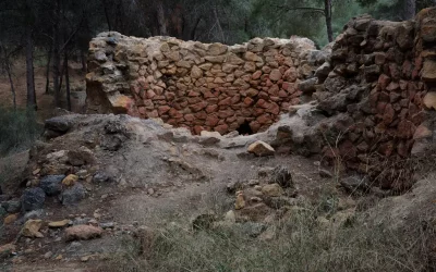
The castle can be distinguished into two well-differentiated enclosures delimited by mortar walls, the same material used to build the walls of Murcia. The upper enclosure is a tower and corresponds to the last bastion of the castle. It is therefore the most strongly defended, it is nestled on top of the hill and its layout adapts to this summit, which is why it presents certain irregularities. It is formed by towers and a bastion. In addition, the remains of numerous structures are preserved that appear to correspond to housing units with walls 50 centimeters thick.

A group viewing the water cistern | Photograph of a cultural routes in collaboration with Joaquín Lomba, Professor of Archaeology at the University of Murcia.
Water cisterns
The lower enclosure, subdivided into two different spaces, is delimited by a wall. Inside, the only structure that remains standing is a cistern that has a vaulted roof, with dimensions of 6’50 x 3’20 meters, and is plastered in red. The wall that forms the outermost enclosure preserves a small quadrangular tower, generating a platform on which we find another cistern of 7’50 x 1’80 meters and is also plastered in red.
Fortress for security
It seems that this enclosure would serve to shelter in situations of danger the inhabitants of the area that today form Algezares, Santo Ángel, La Alberca and El Palmar, and that in its lower part the livestock would also take refuge.
The Archaeological Museum of Murcia (MAM) displays a large amount of material excavated at this castle that testifies to a long period of occupation, from the 8th to the 9th century.
Theories about the Castle’s Origin
The exact time and purpose of the castle’s construction remain unclear, giving rise to various theories.

The Verdolay castle, seen here from the Visitor Centre of La Luz
Abderramán II and the Founding of Murcia
One theory suggests that the castle was built under the reign of Abderramán II, the Emir of Córdoba, in the early 9th century. It is believed that Abderramán II ordered the demolition of Ello, the former capital of the Visigothic Principality of Theodomir, due to its ongoing resistance to Cordoban rule. In its place, he founded the city of Murcia, which became the new administrative center of the Tudmir province.

Part of the Wall and a view of the Visitor Centre
The Location of Ello
The exact location of Ello, the mysterious city of the Pact of Tudmir, remains a subject of debate. Two main theories propose potential sites:
Algezares
This theory is based on the presence of a Paleochristian basilica in Algezares and the results of georadar surveys that indicate the existence of underground structures near the basilica. However, excavation is currently impossible due to the private ownership of the land.
Tolmo de Minateda
This theory suggests that Ello was located at Tolmo de Minateda in the municipality of Hellín (Albacete). Archaeological excavations have unearthed the remains of a city with a Visigothic basilica, leading some to believe it is the site of Ello.

View from the valley road to the tower
A Defensive Network of Settlements
A third hypothesis proposes that the population of the Murcia plain during the Emirate period (from the capitulation of Theodomir in 713 to the founding of Murcia in 825) was concentrated in settlements along the banks of the Segura River, at its confluence with the Guadalentín River, and on the northern and southern edges of the valley. These locations were chosen to avoid flooding and utilize the flow of the ramblas (dry riverbeds that fill with water during heavy rains), as the irrigation network of the Huerta (agricultural land) had not yet been established.
This hypothesis suggests that there were two districts, each under the control of a castle, on opposite sides of the river: Monteagudo Castle to the north and Verdolay Castle to the south. These castles would have served as defensive strongholds and administrative centers for the surrounding settlements.
Water Supply System
Apart from its defensive and residential functions, the castle also had a water supply system that exploited the aquifers of the mountain. This was use full, especially during epidemics of cholera and plague.
Approximately 1 kilometer north of the fortification, at the Sericultural Station, lies a reservoir that archaeologist Manzano believes could be of Roman origin, although it was likely used during the medieval period. At the foot of the reservoir, on flat terrain slightly elevated above the surrounding plain, the remains of Andalusi baths and an aristocratic residence have been unearthed. These structures were likely connected to the abundant springs in the area and serve as evidence of a settlement that may have played a role in the castle’s function.

Image from the video “El sistema hidráulico de Santa Catalina del Monte” by Valentín Sarabia
State of the castle
The poor state of the castle ruins necessitated consolidation work in 1998. Surprisingly, this small excavation marked the first systematic exploration of this unique and enigmatic monument. Despite the limited scope of the excavation, the research team proposed the following interpretation of the site’s historical sequence:
- Early Occupation Phases: The site exhibits evidence of undefined occupation phases dating back to the Bronze Age and the Iberian period.
- Castle Construction: The castle itself was constructed sometime before the 11th century.
- Transformation into a Fortified Palace: During the 12th century, the fortress underwent a transformation into a fortified palace.
- Destruction and Reconstruction: The pre-existing palace was eventually destroyed and reconstructed during the Almohad period.
A fortified palace
The identification of this castle as a palace is surprising, but the author bases it on the discovery of abundant decorative remains (plasterwork), which certainly correspond more to a residential building than a military one. Future excavations may confirm or disprove this and, in any case, resolve the many doubts that still persist about this building.

Valentín Sarabia during the video recording of the hydraulic system found under the Castle
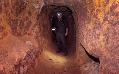
Ancient legends of hidden passages
We have always heard ancient legends about hidden passages that would connect the castle with Santo Ángel, La Alberca and the area of the hermitage of La Luz. Recently, three levels of galleries have been discovered under the castle, a total of more than 200 metres in length and 80 metres deep.
On the first level of the uncovered galleries there is a large room with a domed roof, two wells and stairs leading to the second level. On the second level there are two large tanks for storing water and other stairs leading to the third level, which is completely flooded and whose extent and depth are not yet known.

Part of the castle wall
The mountain’s aquifers
Although the main purpose of these galleries was to exploit the mountain’s aquifers, there is also evidence of mining use. So far we have not been able to confirm which minerals were sought in this area of the mountain.
Without certainly knowing the original origin of the galleries, it is suggested that they supplied water to the community of friars of the Convent of Santa Catalina del Monte some 250 years ago and that the mine/aquifer was reused by the City Council of Murcia at the end of the 19th century to provide the city with drinking water during the cholera and plague epidemics that struck the region.

View of the dome of the hydraulic system under the Verdolay Castle
Amazing stories
One thing is clear: many civilizations have passed through this high part of our village. It is a historical place that never ceases to amaze us, and that in the near future will surely hold new surprises for us.

The Verdolay Castle also known as the Castle of the light
The original history was written by the chronicler Ángel Matas, a resident of Santo Ángel. For many years, I provided the photos to accompany his articles. You can find the original story at: El Castillo de Verdolay.
Contact us
Unveiling the wonders of Murcia: Embark on a journey of discovery and immerse yourself in the rich culture, breathtaking landscapes, and captivating traditions of Murcia. Explore the hidden gems and captivating charm of Murcia: Let us guide you through this enchanting region, from its sun-kissed beaches to its ancient castles and vibrant cities. Contact us today to plan your unforgettable adventure.
Photographs:
Jerôme Van Passel